Gulf of Mexico 'dead zone' Larger than Average, Scientists Find
September 22, 2024
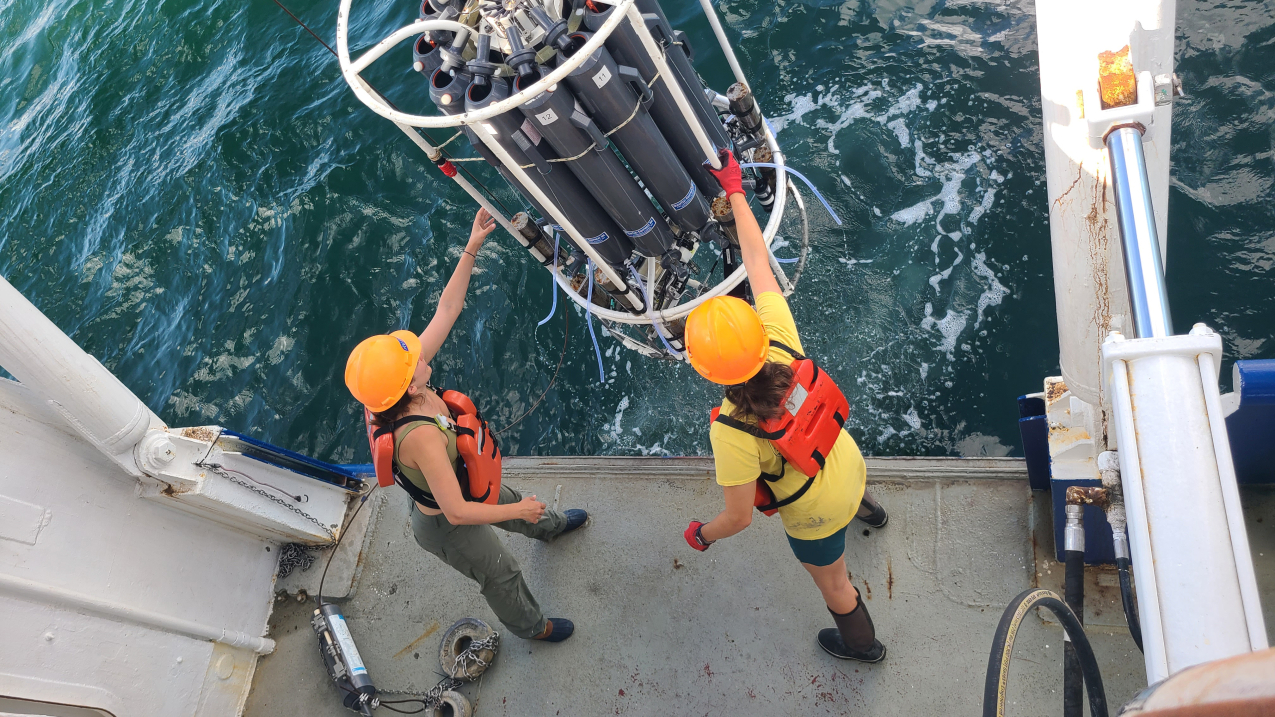
Dr. Jill Tupitza and doctoral student Allison Noble collect near-bottom water aboard Research Vessel Pelican to obtain oxygen measurements used to determine the size of the Gulf of Mexico hypoxic zone. (Image credit: LUMCON/LSU, Cassandra Glaspie)
NOAA-supported scientists announced today that this year's Gulf of Mexico "
dead zone" — an area of low to no oxygen that can kill fish and marine life — is approximately 6,705 square miles, the 12th largest zone on record in 38 years of measurement. This figure equates to more than 4 million acres of habitat potentially unavailable to fish and bottom species, an area roughly the size of New Jersey.
Scientists at Louisiana State University and the
Louisiana Universities Marine Consortium (LUMCON)offsite link led the annual dead zone survey July 21–26 aboard LUMCON research vessel Pelican. This annual measurement is a key metric that informs the collective efforts of the
Mississippi River/Gulf of Mexico Hypoxia Task Force, a state/federal partnership which has set a long-term goal of reducing the five-year average extent of the dead zone to fewer than 1,900 square miles by 2035.
While the NOAA-supported research surveys provide a one-time snapshot of the
dead zone, the five-year average captures the dynamic and changing nature of the zone over time. The five-year average size of the dead zone is now 4,298 square miles, more than two times larger than the 2035 target.
"It's critical that we measure this region's hypoxia as an indicator of ocean health, particularly under a changing climate and potential intensification of storms and increases in precipitation and runoff," said Nicole LeBoeuf, assistant administrator of NOAA's National Ocean Service. "The benefit of this long-term data set is that it helps decision makers as they adjust their strategies to reduce the dead zone and manage impacts to coastal resources and communities."
In June,
NOAA predicted an above-average sized dead zone of 5,827 square miles, based primarily on Mississippi River discharge and nutrient runoff data from the U.S. Geological Survey. The measured size fell within the uncertainty range for
NOAA's ensemble forecast, demonstrating the overall accuracy of the underlying models and their ability to be applied as tools for nutrient reduction strategies.
"The area of bottom-water hypoxia was larger than predicted by the Mississippi River discharge and nitrogen load for 2024, but within the range experienced over the nearly four decades that this research cruise has been conducted," said Nancy Rabalais, Ph.D. professor at Louisiana State University and LUMCON, and co-chief scientist for the cruise. "We continue to be surprised each summer at the variability in size and distribution."
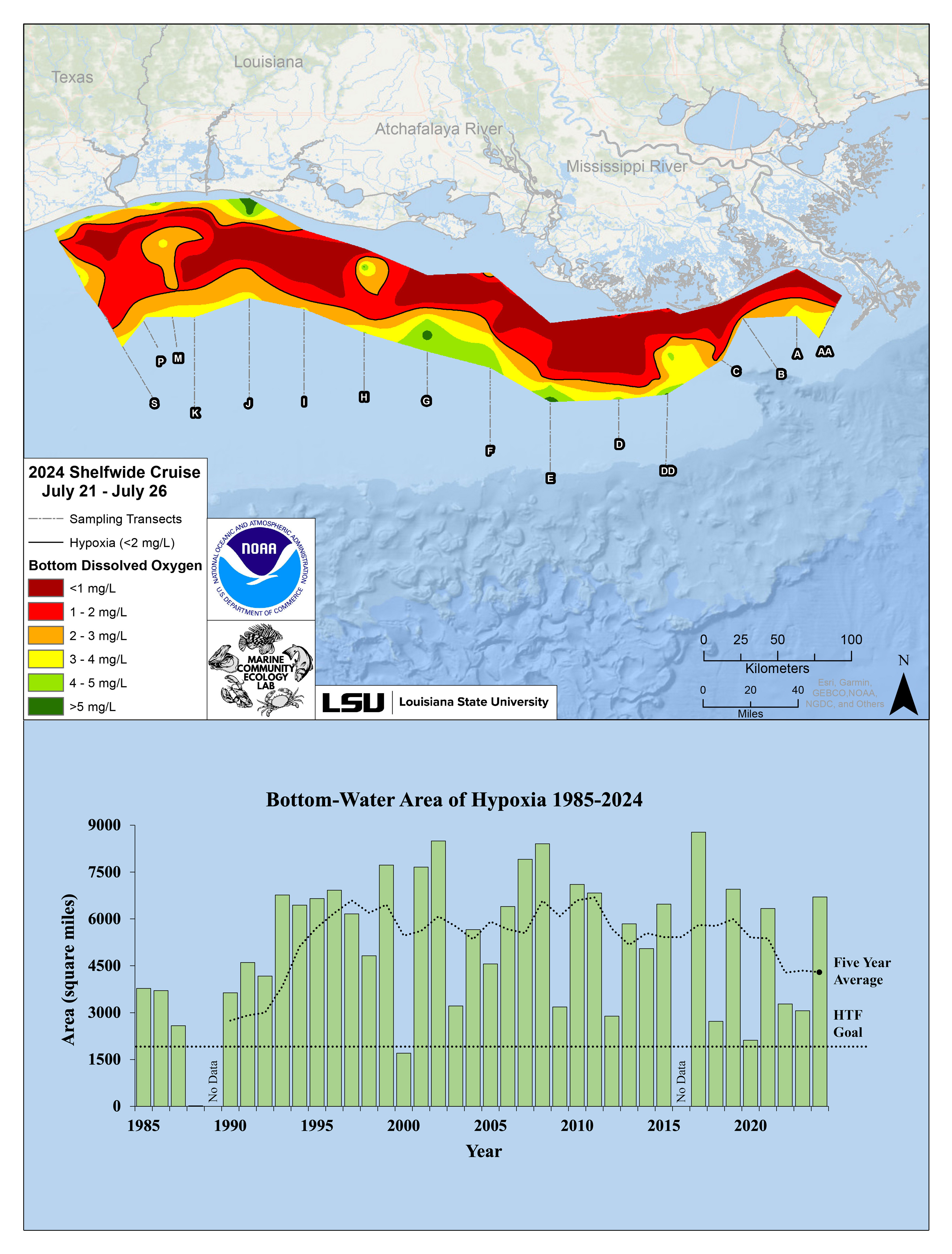
Image showing (Top) Map of measured Gulf hypoxia zone, July 21–26, 2024. Red area denotes 2 mg/L of oxygen or lower, the level which is considered hypoxic, at the bottom of the seafloor. (Bottom) Long-term measured size of the hypoxic zone (green bars) measured during the ship surveys since 1985, including the target goal established by the Mississippi River/Gulf of Mexico Watershed Nutrient Task Force and the 5-year average measured size (black dashed lines). (Image credit: NOAA/LUMCON/LSU)
How dead zones are formed
Excess nutrients that reach the Gulf of Mexico via the Mississippi-Atchafalaya River Basin stimulate an
overgrowth of algae. When these algae die and decompose, they deplete oxygen in the water as they sink to the bottom. The resulting low oxygen levels (hypoxia) cause animals, like fish and shrimp, to leave the area. Exposure to hypoxic waters has been found to
alter fish diets, growth rates, reproduction, habitat use and availability of commercially harvested species such as
shrimp.
Hypoxia Task Force efforts
In June 2022, the Environmental Protection Agency (EPA) established the
Gulf Hypoxia Program to further accelerate nutrient reduction actions by the Task Force to make significant progress toward the Task Force's
Gulf Hypoxia Action Plan.
"Nutrient pollution impacts water bodies across the country and in the Gulf of Mexico it has resulted in a dead zone, where low to no oxygen does not support fish and marine life," said Bruno Pigott, acting assistant administrator of EPA's Office of Water. "EPA is committed to its partnership with state and local governments and Tribes in the Mississippi-Atchafalaya River Basin, working together to reduce nutrient pollution and protect the health of the Gulf. In fact, thanks to President Biden's Bipartisan Infrastructure Law, EPA is investing $60 million into this effort."
As a result, the Hypoxia Task Force states are scaling up their nutrient reduction strategies while increasing climate resiliency and ensuring benefits are realized by disadvantaged communities.
"The importance of the Mississippi River to the strength and growth of our states' economies and communities cannot be understated," said Mike Naig, Iowa Secretary of Agriculture. "By implementing our nutrient reduction strategies, the Hypoxia Task Force states are individually and collectively demonstrating our commitment to protecting and enhancing this working river. Weather and other factors will always introduce variability in the hypoxic zone measurement from year to year, but the focused conservation implementation work within each state is making a positive impact on our water quality. States, along with numerous public and private partners, are best positioned to address their specific geographies and we remain motivated to expand this proven water quality work in rural, suburban and urban landscapes in the years and decades to come."
Further work to better understand and predict dead zones
In addition to its annual hypoxia forecast and survey, NOAA supports efforts to develop monitoring technologies to understand the dead zone, as well as to study the impacts of hypoxia on fish and fisheries in the Gulf of Mexico and elsewhere through its
Coastal Hypoxia Research,
Ocean Technology Transition,
Uncrewed Systems and
Hypoxia Watch programs. The agency continues to partner with states to develop
new tools to predict nutrient runoff to waterways and to support the
Northern Gulf Instituteoffsite link to deliver technical assistance, observation and monitoring capabilities.
NOAA scientists are also investigating the feasibility of using autonomous surface vehicles (ASVs) as an emerging technology to map hypoxia in the Gulf of Mexico. This year, several ASVs were deployed in coordination with the measurement survey, which will be compared with the ship-based measurements.
The original article can be found at
www.noaa.gov.
