NOAA and NGI Scientists Publish a New River Chemistry and Discharge Dataset for U.S. Rivers
June 7, 2023

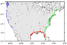
Figure 1: USGS stations used to derive river chemistry patterns. Green, red, and blue dots correspond to rivers discharging to the US East Coast, Gulf of Mexico, and US West Coast, respectively. Graphic submitted
A new river chemistry and discharge dataset for U.S. coasts has been released. A
recent publication by scientists at
NOAA's Atlantic Oceanographic and Meteorological Laboratory (AOML),
Northern Gulf Institute (NGI), and
NOAA's Geophysical Fluid Dynamics Laboratory (GFDL) provides a river chemistry and discharge dataset for 140 U.S. rivers along the West, East, and Gulf of Mexico coasts, based on historical records from the U.S. Geological Survey (USGS) and the U.S. Army Corps of Engineers. This dataset will be very useful for regional ocean biogeochemical modeling and carbon chemistry studies.
Ocean biogeochemistry models are widely used to simulate, forecast, and study marine ecosystems, ocean carbon chemistry, ocean acidification, ocean productivity, and fisheries. In recent years, there has been an increasing focus to better understand and quantify the influence of river inputs on U.S. coastal ecosystems. This is reflected by the growing number of ocean biogeochemical modeling studies that address river-induced ocean patterns. However, to properly simulate coastal ecosystem responses to river runoff, these models need realistic inputs of river-water properties such as nutrients, alkalinity, and dissolved inorganic carbon concentration.
Additionally, understanding river discharge impacts is important because they can play a role in hurricane intensification and forecasting. In a study by scientists at AOML, it was found that the
Mississippi River plume played a key role in the intensification of Hurricane Michael in 2018. The very intense density gradient between the fresh river waters in the surface layer of the Mississippi plume and the saltier ocean waters below inhibited the mixing of these two water masses. This resulted in the surface layer maintaining high sea surface temperatures and providing conditions that were favorable for hurricane intensification.
There is a growing need for river chemistry data, especially carbonate system variables such as alkalinity and dissolved inorganic carbon, to reduce uncertainties linked to the flow of carbon and nutrients from land to coastal waters. To help fill this gap, a research team led by NOAA and NGI scientists developed the new data product for ocean-biogeochemical model applications that characterizes the river chemistry for 140 U.S. rivers.
"This new dataset integrates and standardizes historical USGS information from nearshore monitoring river sites, making readily available a full set of river chemistry variables needed as inputs for ocean-biogeochemical models, including novel estimates of dissolved inorganic carbon. It is also useful for skill assessment of hydrological and nutrient load models," said Fabian Gomez, an NGI/AOML researcher and lead author of the publication.
The dataset, named RC4USCoast, provides a monthly time series, as well as a long-term averaged monthly climatology, for 21 chemical variables, including alkalinity, pH, dissolved inorganic carbon concentration, and nutrients. The dataset is derived from the USGS's Water Quality Database, along with river discharge data from the USGS's Surface-Water Monthly Statistics for the Nation and the U.S. Army Corps of Engineers. It can be
downloaded through NOAA's National Centers for Environmental Information (NCEI).
The goal of this work was to develop a U.S. River chemistry dataset for use in NOAA's next-generation operational ocean modeling and decision support system, which aims to reduce impacts, increase resilience, and help marine resources and resource users adapt to changing ocean conditions.
By
AOML Communications to
Ocean Chemistry and Ecosystems,
Physical Oceanography
