Making Data Collected by Research Vessels Usable to Support Weather Forecasts
April 23, 2025
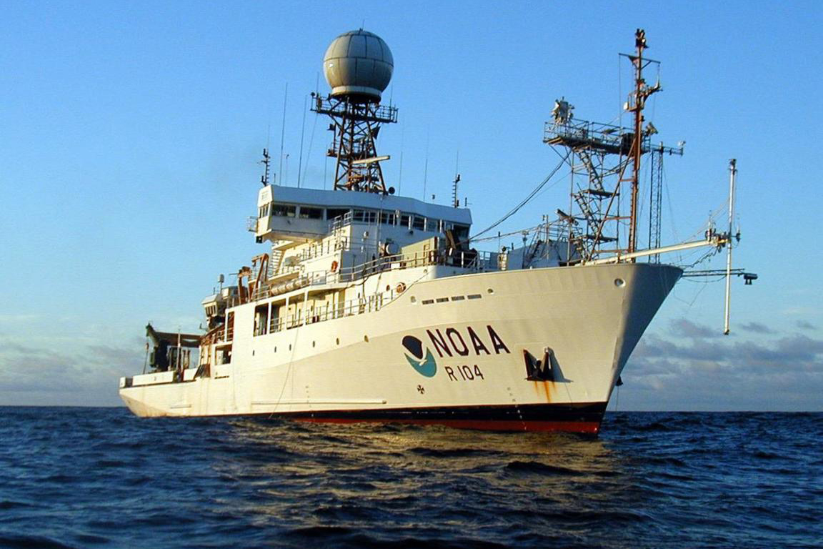
The Ronald H. Brown, the largest ship in the NOAA fleet, is equipped with a suite of instruments to collect scientific data above and below the ocean surface, allowing simultaneous measurements of the atmosphere and ocean.
Credit: NOAA Office of Marine and Aviation Operations
One of the first things we do every day is check the weather. The information that weather stations and apps provide is reliable because it is based on environmental data that modeling systems use to generate forecasts.
An essential source of environmental data for these modeling systems is collected remotely by satellites. But before forecast modeling systems can use satellite-collected environmental data, the data must be verified with meteorological and oceanographic observations, some which are collected by research vessels at sea.
Data managers with the Northern Gulf Institute (NGI) at Florida State University (FSU) process environmental observations collected at sea and upload them to platforms for use by developers of satellite data products that forecast modelers use, making it possible for us to get the weather information we need to go about our daily lives.
Providing value to American taxpayers is a key outcome of the work that these data managers provide. "Air and ocean observations collected by U.S. research vessels is at the taxpayer's expense," explains Shawn Smith, Senior Research Associate at the Marine Data Center with the FSU Center for Ocean-Atmospheric Prediction Studies. "These data need to be complete, accurate, and freely accessible to scientists, policy makers, and the public for use now and in the future so that taxpayers get their money's worth."
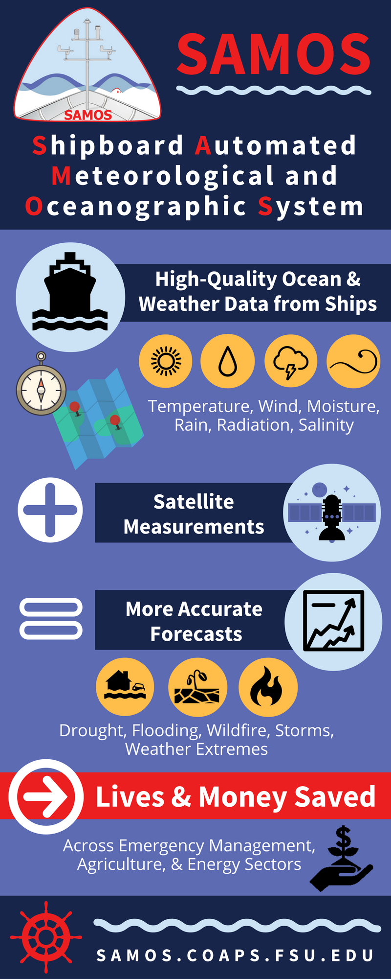
Smith manages the U.S. Shipboard Automated Meteorological and Oceanographic System (SAMOS) Data Assembly Center (DAC) whose work involves processes ranging from how data is gathered at sea to how that data is ultimately made accessible for algorithms that support weather forecasts.
"The SAMOS project within the DAC provides foundational high-quality meteorological and near-surface oceanographic data to support an expanding research and operational user community," Smith explained. "SAMOS data are used to ground truth satellite observations and improve satellite datasets, which are a primary input to numerical models, subsequently improving weather forecasts."
Here is a peek at the work Smith and his team at the SAMOS DAC do that play an important role in our getting reliable weather forecasts.
Data Collection at Sea
Collecting environmental data is the starting point for weather forecasts. With funding from the National Oceanic and Atmospheric Administration (NOAA), National Science Foundation (NSF), and Schmidt Ocean Institute, the SAMOS DAC receives and processes environmental data collected across the globe by 31 oceanographic vessels – about half of which NOAA operates – equipped with instrumentation that capture wind speed, ocean salinity, air and sea temperature, atmospheric pressure, moisture, solar radiation, and rainfall.
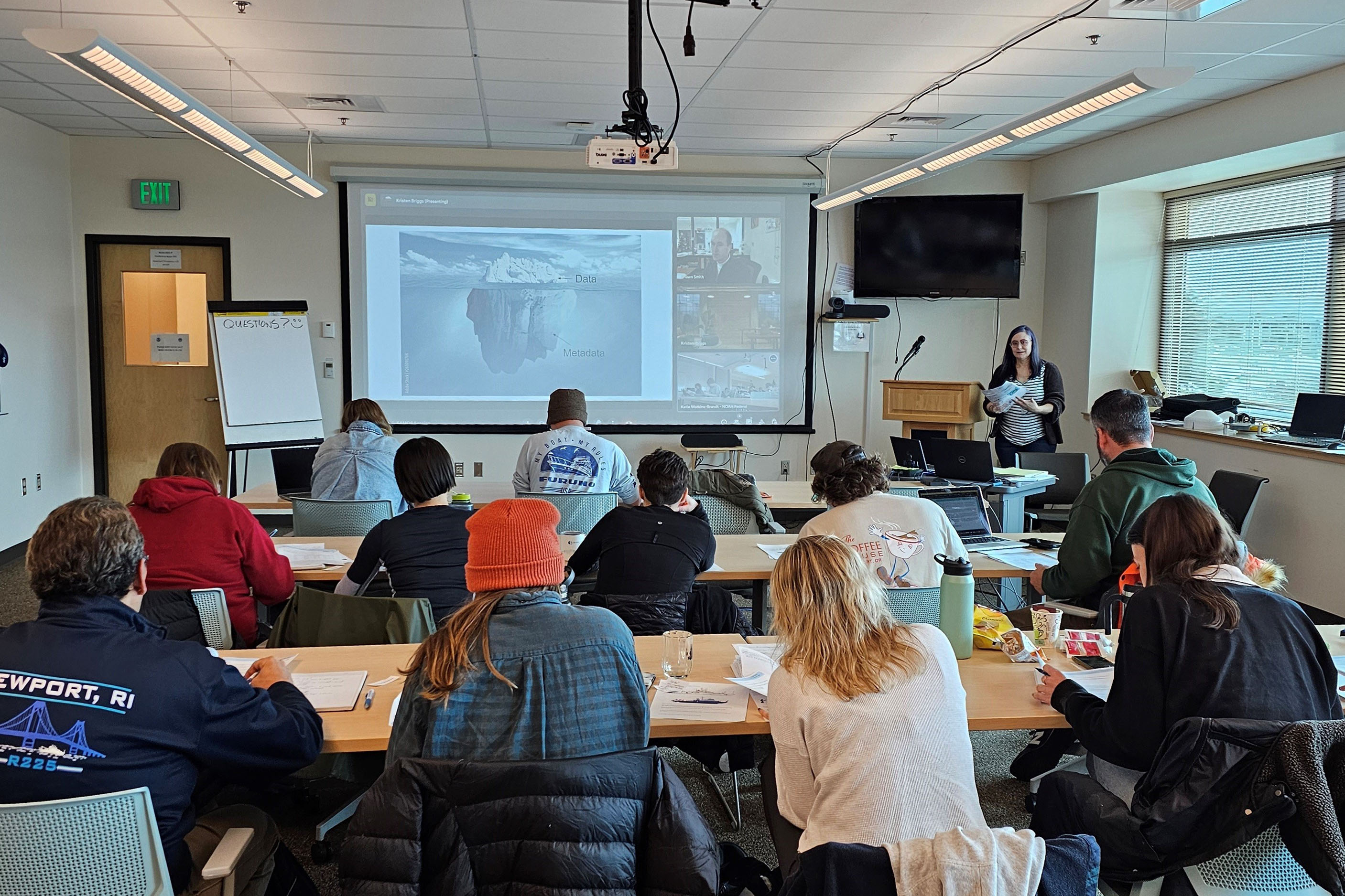
Kristen Briggs, a SAMOS DAC specialist at FSU, leads a training session for NOAA marine technicians on best practices for weather instrumentation and observation on research vessels. The NOAA Marine Operations in Newport, Oregon hosted this training.
Credit: Katie Watkins-Brandt, NOAA/OMAO, MOC-P.
Marine technicians aboard these vessels operate and maintain the vessel's instruments, and Smith and his team routinely interact with them. "We provide training for, and virtual vessel walk-throughs with, technicians to ensure best practices are used for sensor deployment and data acquisition. During expeditions, we assist them with troubleshooting, which increases their proficiency to identify and fix sensor problems."
Smith and his team also benefit from these interactions as technicians give field-based insight into sensor operations that help shape training and data management plans. "The success of the SAMOS DAC would not be possible without the contributions of the marine technicians and crews sailing the research vessels and contributing environmental observations," acknowledged Smith.
Another way that Smith and the SAMOS DAC team help data collection at sea is by regularly participating in NOAA marine operation center meetings to review the condition of and configurations for sensing instruments, which affect quality control of data. Smith and his team also provide input on standardizing meteorological sensors and operational guidance across the NOAA fleet to improve data quality.
Management for Data Usability
"Scientists don't just want access to a lot of data," Smith said. "They need to know that data they use have been validated, meaning they have been checked for accuracy and inconsistencies. When a researcher downloads a SAMOS data file, they don't just get a string of letters and numbers, they also get detailed metadata about the environmental observations."
Examples of metadata include the way air temperature is measured (Fahrenheit or Celsius), how wind speed is reported (miles per hour or meters per second), how far above sea level the barometer is located, and how a ship reports its course (degrees clockwise or counterclockwise). Even knowing a sensor's location on the vessel is a factor that contributes to forecast accuracy.
"Some ships gather water temperature with a thermometer placed directly in the water, making the measurement very similar to the ocean temperature where the vessel is sailing," explained Smith. "Sometimes, though, ships pull water from the ocean inside to a lab before taking temperature measurements, which can be affected by the ship's heating or cooling systems."
Credit: Meredith Field, FSU COAPS, December 2016.
The transfer of metadata from vessels to the SAMOS DAC is now an automated process thanks to software developed by NOAA's Office of Marine and Aviation Operations with input from Smith and his team. Having these important details attached to environmental observations allows researchers to adjust their calculations, which contributes to forecast accuracy.
Scientists also need data that have been checked for quality. "Our computerized quality control system attaches flags to data irregularities like spikes and dips, which can happen when a sensor becomes contaminated by a ship's exhaust or during extreme weather such hurricanes or fronts," Smith said. "Our data analysts review flagged data and add or modify flags to help users understand when an irregularity in the data is caused by a sensor problem or when it is the result of a real weather event. This allows a data user to know what they are looking at and decide how or if to use the flagged data."
Data Accessibility and Use
Smith and his team distribute all quality-controlled SAMOS observations via the
world wide web,
web services, file transfer protocol, and
THREDDS services and ensure routine
archival at the National Centers for Environmental Information. How much data are we talking about? For the NOAA-funded effort in 2024, Smith and his team received and processed navigational and environmental data for ~3,300 ship days from 19 research vessels. Data from the 15 NOAA vessels accounted for 95% of the days NOAA vessels were at sea, well above their 90% target.
These data are also useful for an expanded array of weather-related efforts. "SAMOS observations are often collected in remote ocean regions, adding much-needed data to improve our understanding of the range of possible weather and surface ocean conditions across the globe," explained Smith. "The uniqueness of these observations makes them ideal for studies on marine climate and ocean process and for evaluating numerical models and satellite products that support operational marine weather forecasting."
**********
Researchers involved with the SAMOS DAC are Shawn R. Smith, Mark A. Bourassa, Kristen Briggs, Julia O'Neill, E. Michael McDonald, and Amanda Lovett. Partners include NOAA National Centers for Environmental Information (NCEI) and Physical Sciences Laboratory (PSL), the Australian Integrated Marine Observing System, and members of the NSF Rolling Deck to Repository project and NOAA's International Comprehensive Ocean Atmosphere Data Set project.
This research supports five NOAA Line Office missions: National Environmental Satellite, Data, and Information Service (NESDIS), National Marine Fisheries Service (NMFS), National Weather Service (NWS), Office of Marine and Aviation Operations (OMAO), and Office of Oceanic and Atmospheric Research (OAR).
The
Shipboard Automated Meteorological and Oceanographic System aims to improve the quality of meteorological and near-surface oceanographic observations collected in-situ on research vessels and select volunteer observing ships.
The
Northern Gulf Institute is a NOAA Cooperative Institute with six academic institutions located across the U.S. Gulf Coast states that conducts research and outreach on the interconnections among its regional ecosystems for informed decision making.
By
Nilde Maggie Dannreuther with the Northern Gulf Institute at Mississippi State University and
Shawn R. Smith at Florida State University.
